Features

The essentials

And more

Who it's for
PricingAbout
Maps

Your knowledge of the ground, visible to everyone.

Draw your zones, stands and drives directly on the IGN map. Share them in real time with every participant.

Free to startiOS · Android · Web

The same map for everyone

Draw your hunting ground on the IGN map, the satellite view or the land registry. Every participant finds the map on their phone, on the morning itself.

  • IGN map, satellite and official land registry
  • Shared with members by private link
  • Map prepared for offline use
Try the hunting map for free, no account needed
Satellite view of a hunting map

Your plots drawn with no pencil

Tap a plot: Mes Chasses picks up its exact contours from the official land registry. The lasso adds several in one go.

  • One plot added with a tap
  • Zone merging and removal as needed
  • Surface area calculated in hectares
Auto-trace of hunting land registry plots

Stands, high seats, one map per drive

Place each stand with its number and type. One map per drive, legible even when the ground has one hundred and fifty of them.

  • Ground stand, high seat, stand hunting, pigeon hide
  • Route to the stand, on foot
  • Random hunter placement
Invitations to driven hunts
Satellite view with high seats and hunting stands

Firing sector visible to everyone

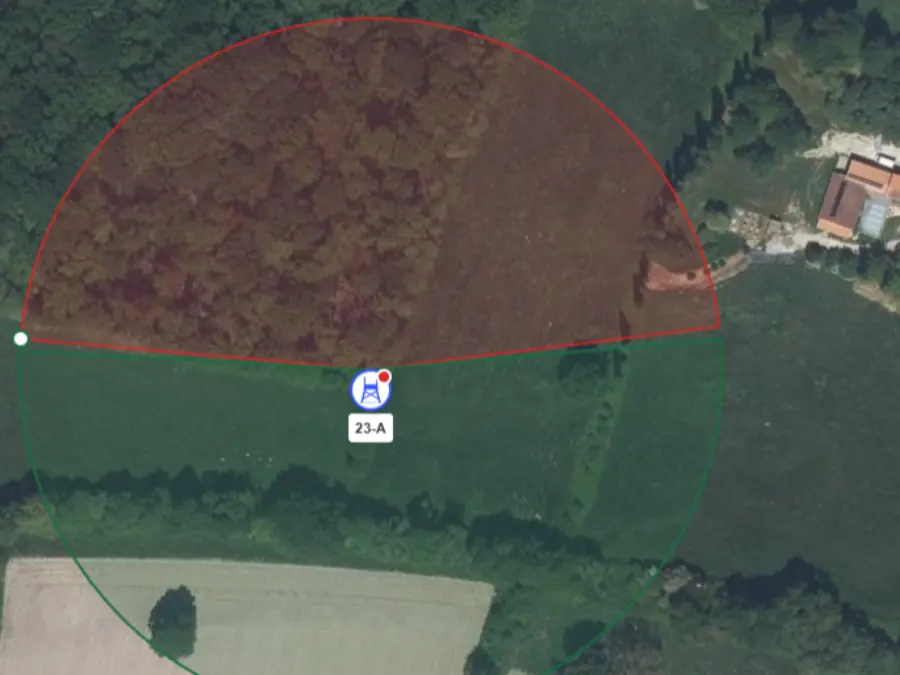
Set the authorised firing angle of each stand. Mes Chasses flags a stand too close to a house, a road or a power line, for guidance.

  • Firing angle drawn stand by stand
  • Alert for house, road, railway
  • Live alert when leaving the ground
Try it for free
Firing sector of a high seat on the hunting map

Ready to make your hunts simpler?

Join the associations using Mes Chasses. Free to start, no credit card required.

They use Mes Chasses

What they say about us

What hunters and organisers say about their experience with Mes Chasses.

+1 000hunting grounds equipped
87departments covered

« For me, the maps are the cornerstone of the app. I explain my ground with that. »

G
Gérard P.
Driven hunt organiser, Vosges

« There are no tools to make maps for hunting. Now there's you. QGIS is very complicated. »

B
Bernard L.
Hunting society secretary, Indre

« In the morning, I set up the projector, I show the day's map, I put the stands on screen, I remove the ones I'm not interested in, in two seconds. »

T
Thierry R.
Line leader, Maine-et-Loire

Frequently asked questions

Mes Chasses uses the IGN Plan, IGN aerial photographs (satellite view, with several years to choose from) and the official land registry. You switch from one base to another with a tap and show only the useful overlays: relief, public forests, power lines, Natura 2000 zones.
Tap a land registry plot: Mes Chasses adds it to your zone with its exact contours, pulled from the official land registry. The lasso picks several in one go. The area is calculated in hectares. It replaces a day of manual work with paper maps.
Yes. For each stand, you set the authorised firing angle, visible to participants on the map. Mes Chasses also flags a stand too close to a house (150 m), a road or railway line (100 m), a power line or another stand. It is for guidance: the decision to shoot stays with the shooter.
You share the map with the ground members, by link or publicly. During a live hunt, each participant finds it in the mobile app. The organiser can prepare the hunt zone so it stays available offline.
It shows where the animals seen, harvested, wounded or missed during your hunts are concentrated. You spot the most hunted areas and adjust how you run your drives from one season to the next.
Yes. On the web, you import your Google My Maps (KML), your GPS tracks (GPX), your Géoportail files (GeoJSON) or an Excel sheet of coordinates. You can then print the map as a PDF, from A5 to A1, with grid, scale and north arrow, or export it to GPX and KML.
More than one hundred and fifty types of points of interest: car parks, feeding points, water points, game trails, cameras, danger zones, tree or animal markers. Each overlay shows or hides with a tap, and relief, contour lines and slopes layer over the base map.

Manage less. Hunt more.

Join the associations running their driven hunts with Mes Chasses.

Free to startNo credit cardiOS · Android · Web